Friday 25 November 2022

Signs of Nature, and Then Some

As we work on the digitisation of the marvellously rich Alonso de Chaves’ Quatri Partitu (ca. 1537), I was struck by the brief last treatise of Book Two, “On the Natural Signs to Know the Weather Changes” (fols. 37r–44v). The treatise has a very clear structure: there are ten significants or indicators in nature, which through their changes tell us about five variables (“diez señales de cinco diferencias”)—variables which are of course of particular interest to mariners.

The ten signs are stars, sun, moon, clouds, fog, rainbow, lightning and thunder, fowl and fish, land animals, inanimate land and water bodies. The five variables are calm, wind, rain, tempest, and cold. This means that we have subheadings for combinations like: “Signs of tempest given by the rainbow”, and “Signs of calm given by lightnings and thunder” and so on.

On one hand, rather objectively, the detail of the observation of nature is delightful and often lyrical or comical: “When the stars appear to move or play and they are dancing, it signifies winds coming on the following day from the region where they are most clearly visible,” “When the owls hoot by sunset, it signifies rains,” or “When fleas bite more than usual, it signifies imminent rain.” Another example, under “Inanimate bodies”, is this, “When leatherwear and belts are rougher and harder than usual, it signifies storms.” Chaves is quick to note, as a conclusion to this section, that “of these signs, some are general and some particular. Not one of them is so general that it applies all over the world, and not one is so particular that it applies to one single place or people.” He also notes that they are affected by the phases of the moon and by the seasons, and that some of them combine in certain ways.

On the other hand, thinking of the contrast with our modern meteorology and its impressive feats, one cannot shake off a sort of je ne sais quoi, a feeling of nostalgia perhaps, of a more direct involvement with nature and its every little sign—a love relation really. Or perhaps it is a feeling of simple heuristic wonder at the possibilities still awaiting meteorology in its development. After all, meteorology as an ongoing endeavour is always hot on the tracks of the butterfly effect, and it probably will at some point start paying attention to those butterfly wings! [Juan Acevedo]

Friday 18 November 2022

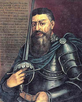
Esmeraldo de Situ Orbis, a Book of Secrets

Half-forgotten and out of sight for centuries, Esmeraldo de Situ Orbis (1505–1508), by Portuguese navigator and cosmographer Duarte Pacheco Pereira (1460–1533), is a technical treatise describing the African ports known by Portuguese mariners sailing to India, following Vasco da Gama’s (1469–1524) discovery of this nautical route (1497–1498).

The “Prologue” of this veritable treasure chest of maritime rutters, which allowed King Manuel I (1495–1521) to rule the trade from Asia to Europe, offers to the historian of science an unexpected gift – the very modern idea that the wealth and fame of a kingdom is a consequence of scientific and technological achievements:

We can say that the glory of your victories and the praise of your name and great navigation and conquest is related to Menelaus & Hanno the Carthaginian & Eudoxus, whom the authors celebrate and mention so much, & also to all the Kings and princes your predecessors; & how in so little time your Highness has discovered almost one thousand and five hundred leagues beyond all the ancients and moderns that had never been known or navigated by any nations of our west (…).

By specifying the giants whose shoulders’ King Manuel is standing on, Pacheco Pereira sets the monarch’s success on two pillars. On one side, the author refers to Menelaus of Alexandria (c. 70–140 CE), a Greek astronomer and mathematician who studied the geometry of the sphere and how it can be applied to astronomical measurements and calculations; and to Eudoxus of Cnidus (c. 408 BCE–355 BCE), another Greek astronomer and mathematician, also dedicated to the study of spherical astronomy, crucial for Early Modern celestial navigation. On the other side, the author refers to Hanno the Navigator (c. 500 BCE), the mythical Carthaginian navigator and author of Periplus Hannonis, an itinerary detailing a voyage of exploration and colonization from Carthage down the coast of West Africa to the Gulf of Guinea, the type of text that precedes the oceanic rutter, certainly an inspiration to the Esmeraldo.

These pillars for the glory of Early Modern Portugal are, on the one hand, astronomy and mathematics, the scientific disciplines that allow for a pilot in the middle of the ocean to make a correct measurement of latitude. On the other hand, the practice itself of navigation, made possible by the pilot’s knowledge of celestial navigation using instruments — a practice guided by charts and rutters, the secret for the Portuguese kingdom to establish a maritime route made of safe, and repeated, roundtrip voyages, which ultimately led to the creation of a global empire. [Joana Lima]

Friday 11 November 2022

From the Ship’s Angle

In early modern times the ship, as a means of transport, was an old invention. However, its use in the new context of high-seas navigation and long-distance voyages changed deeply the way of understanding travel, the relation with space and time, and a concrete perception of the world.

A new way of reporting the world was witnessed and made evident by pilots in their nautical rutters.

Nautical rutters fulfilled perfectly their primary task, that was informative, with a neutral language, with a synthetic prose and a pragmatic second person plural. In such an information flow devoted to the reliability of data gathering, the texts should not reach a tone of stylistic pleasantness or elegance. Even so, surprisingly, figurative discourses were not completely absent, and one can find them especially related to the observation of coast profiles.

The images used by pilots were very significant because they represented a piece of world that was not visible from all directions; instead, it was visible only from one specific angle. The observer’s location coincided with the position of the ship at a very precise navigational moment which was the best for a safe navigation.

Figueiredo’s rutters collection was a receptacle of such images. The images were related to pilots’ everyday life, like shipbuilding, known animals, or even food.

An island’s tip could be described by sailors as the spur of a galley (“esporão de galé”), or another could look like a galley with a covered poop (“galé toldada”). Some islands could bring to mind a round bread (“pão redondo”) rising above the sea, or delicious sugar bread (“pão de açucar”) as the Islands Estácio and Saba did. Very common were also the similitarities of coasts with some chess pieces, to indicate especially high peaks, as well as animal heads (like turtle-head or dolphin’s snout).

Such details were never useless: placing themselves in relation to the object observed (with specific expressions like coming from the north side, moving in North-South direction, etc.), the pilots thus reinforced an intrinsic practical value. [Luana Giurgevich]

Friday 4 November 2022

Stars in History of Science

Very exciting news for the field of history of science came out about a month ago: the first known star catalogue ever written was finally discovered in an old parchment originally kept at St. Catherine’s Monastery, in Sinai, Egypt. The parchment consists of 146 leaves of Syrian texts containing –behind them– a palimpsest, which is an older work that has been scraped out.

Scholars and scientists are now able to access palimpsests such as these using multispectral imagery. What they found in the case of this parchment was a set of coordinates for the position of stars belonging to the Corona Borealis constellation. As stars are seen to be shifting slowly to the west in a movement known as precession, the values are different from the modern ones and –more surprisingly still– they even differ from those given by Ptolemy in the oldest catalogue extant. So, the question that remained was: whose measurements were they? And when were they taken? By accounting for the movement of precession, it was possible for scholars to determine that the coordinates were taken around the second century B.C. and would most likely belong to the ancient astronomer Hipparchus, whose catalogue is known only because it was mentioned by later authors.

Stars are a fascinating topic for us members of the RUTTER project, for they played a crucial role in navigation. Latitude measurements at night were based on the determination of the position of the Poles through visible stars –Poles which were still relatively distant from Polaris and even more so from the Southern Cross, in the northern and southern hemispheres respectively. Longitude values, although not so frequent, could also be taken through the stars. The lunar distance method, for instance, could be used by measuring the angular distance between the moon and a particular fixed star in two different places. Sailors in the Indian Ocean had also developed a stellar compass rose in which the rising and setting position of 16 stars would mark the cardinal points and, thus, serve as indicators of direction.

It was with great excitement that we read about such an amazing historical finding as a part of Hipparchus star catalog, and we wonder at the potential impact that this discovery will have. [Inês Bénard]