Showing posts with label cartography. Show all posts

Friday, 22 March 2024

No Country for Mercator’s Charts

It is well known that Mercator charts took a long time to become a common instrument in the nautical panoply of Early Modern pilots. Gerard Mercator (1512-1594) published his Ad Usum Navigatium—the earliest Mercator projection chart—in 1569, and Edward Wright (1561-1615) his Certain errors in Navigation—containing the relevant mathematical tools for constructing such charts—in 1599, but it was still almost two centuries before European Early Modern pilots decided that they were worth using. Cosmographers and mathematicians of the time blamed this decision on the conservatism and scientific illiteracy of the pilots, a representative case being that of the famous Royal Astronomer Edmond Halley (1656-1742). In the preface to his Atlas Maritimus et Commercialis (1728) one can read:

It is well known that many of our sailors, and some that would be accounted artists are at this day obstinate in the use of the Plain Chart […]. And many of our masters that teach navigation teach what they call plain sailing (and many times that only) to such as are designed to take charge of ships […]. And this they do for no other reason but because they think they can measure distances thereon by a scale of equal parts, rejecting the truly Nautical Chart, commonly called Mercator, because one single scale cannot be fitted to all its parts.

Historians of navigation and nautical science have echoed such view on this issue until our days. The pilots’ decisions on which charts to use, however, have nothing to do with any kind of “conservatism” or “scientific obscurantism”, but with more complex particularities of their epistemological reality. Stay tuned for more news on this subject soon! [José María Moreno Madrid]

Friday, 16 December 2022

Trading Nautical Knowledge and Fidelities: Thomas Stukley, Traitor or a Broker?

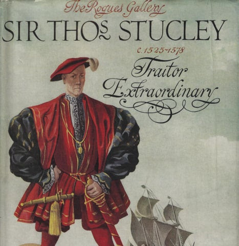
Thomas Stukley (1525–1578) was one of the most commented English military and naval commanders of his time in Europe. Throughout his career, this English Catholic served the Kings of England (Kings Henry VII, Edward VI and Queens Mary I and Elizabeth I), France (King Henry II), Spain (King Philip II), the Papacy (Pope Gregory XIII), and Portugal (he died serving King Sebastian at the Battle of Alcazar-Quibir). Mostly mentioned as a traitor (as in the cover design below), Stukley was also a character who played a role in the processes of nautical knowledge transfer within Europe.

In late 1562, French captain Jean Ribault returned to France from his voyage of exploration to Florida. Arriving at a Dieppe under revolt against King Charles IX, the Huguenot French captain fled to England. There he met Thomas Stukley, who proposed Ribault organizing an Anglo-French expedition to Florida, profiting from French geographical knowledge accumulated during the expedition. When Ribault was jailed in the Tower of London for attempting to flee to France with his knowledge, to return to Admiral Gaspard de Coligny’s service, Stukley took his chance. He hired some of Ribault’s pilots for the expedition, and likely their French nautical rutters and cartography of Florida, and proposed personally to Queen Elizabeth I an English expedition to Florida in 1563. The Queen supported Stukley’s plan but was not aware that, in the meantime, Stukley was also negotiating with the Spanish ambassador in England to enter the service of King Philip II.

In the end, Stukley’s fleet and pilots were employed neither for an English expedition to Florida, nor to join King Philip II’s forces. As he would do several times during his career, Stukley deceived personally Queen Elizabeth I and King Philip II by not entering their service, dedicating himself to privateering. However, Stukley’s renown allowed him to obtain French geographical knowledge. His aborted voyage to Florida in 1563 also influenced all English later plans for voyages and expeditions to the area (for instance it is well-known that William Cecil ordered John Hawkins to visit Florida in his 1564 voyage).

Despite being another polemical moment in his controversial career, Stukley’s aborted English expedition to Florida in 1563 influenced English overseas plans more than it is usually assumed. More than a simple traitor, Stukley was a complex personality and one, among several others in his days, that truly recognized the value of foreign geographical knowledge to plan overseas expeditions. Like other greater explorers such as Hawkins, Drake, Ribault, and Laudonniere, Stukley knew well that he needed to accumulate all the nautical and geographical knowledge before planning his voyage. Thus, in his constant trading of fidelities, Stukley is another example of 16th-century globalization: a key-character brokering nautical knowledge between maritime players. [Nuno Vila-Santa]

Wednesday, 22 September 2021

An Atlas for a French or an English King? Cosmographical Knowledge and Maritime Expansion

Following our previous post on Travelling Cosmographical Knowledge between Elizabethan England and Valois France, we could not resist mentioning an interesting previous case of Anglo-French cosmographical exchange: that of the Dieppe cartographer Jean Rotz.

Born to a Scottish father and a French mother, Jean Rotz became one of the most well-known French Renaissance cartographers at the Dieppe cartographical school. This school was created at the beginning of the sixteenth century to support French maritime expeditions. One of such expeditions was that of the Parmentier brothers to Asia in 1529. It is unclear whether Rotz participated in it. Still, he became acquainted, either by personal experience or by availing himself of important testimonies from crew members, with important knowledge of several parts of Asia, including the East African coasts, the Persian Gulf, the Indian sub-continent, the Indonesian archipelago and the China sea. Rotz’s knowledge was later enlarged when he made a trip to Brazil in 1539 that allowed him to collect information about South America, the Strait of Magellan, the Caribbean and Africa.

Adding this knowledge of the world to European cartography and general rules for Oceanic navigation, Rotz built up a work entitled Book of Hydrography that he intended to present to the French King Francis I. As the Valois monarch did not appreciate Rotz for his work, the celebrated cartographer crossed the border to England, where he ended up dedicating it to Henry VIII. Rotz’s book is still today preserved (and accessible online) in the British Library. Although Henry VIII did not use immediately the amount of knowledge that Rotz was offering him, he understood the importance of keeping such knowledge in his hands, and he protected Rotz until his death in 1547. Only after this date did Rotz return to France due to the French King Henry II’s patronage of the Dieppe cartographical school.

Rotz’s story is, thus, another episode of this Anglo-French exchange of information. If England did not take immediately Rotz’s knowledge to plan maritime expeditions, one should not forget the importance of such acquisitions to the creation of a scientific milieu favourable to maritime expansion. This was precisely what happened when Henry VIII’s successors supported a full-restart of English maritime plans from the 1550’s onwards. Rotz’s case also underscores the historiographical importance of linking history of science and knowledge approaches with imperial maritime histories, in order to have wider and clear perspectives of the different stages of European maritime expansion. After all, English maritime expansion, like the previous French, Spanish and Portuguese, would hardly have happened without these critical episodes of circulation and acquisition of cosmographical knowledge needed to support such a global endeavour. [Nuno Vila-Santa]

Wednesday, 5 May 2021

The Incredible Modernity of Orbis Terrarum Maps

When we look at a medieval planisphere, like the beautiful Mappa Mundi kept at Hereford in England or Ebstorf in Germany, or even the more sophisticated Fra’ Mauro’s map, the first thing that strikes us about it is the very archaic and imprecise appearance, not respectful of what for us is familiarly the image of the continents and seas that make up the earth’s surface. What makes these globes even more eccentric is their sometimes exaggeratedly geometric shape, made of half and quarter circles, which are often populated by mysterious animals and mythological monsters, and represented on a kind of plate that strongly recalls our mistaken belief that men of the Middle Ages believed in a flat earth.

However, if we look more carefully at these kinds of representations of the world, we might perhaps notice some features of surprising modernity. Among the most paradoxical aspects of the world we live in today, in fact, which we habitually call global, is the difficulty we still have in considering the world as a unity. In the medieval Orbis-Terrarum maps the most striking thing is their conceptual effort in representing and conceptualizing the earth globally. In most of these representations the observer is given a universal and unitary conception of the earth. The physiognomy of this is obviously very different from how we know it today, but the lucidity of its global representation, which like every planisphere is a conceptual abstraction, remains surprising.

Certainly their representation of the world reflects a theological vision of reality, for these instruments responded to different needs from those we have today, but they certainly share with modern planispheres the fact that they wanted to embrace the entire surface of the earth, while at the same time trying to respond to the needs of their time, which were essentially of eschatological nature. When we look at one of these representations of the earth’s surface in the future, let us remember that it is precisely in their theological universalism that are the foundations of the modern concept of a global world. [David Salomoni]

Wednesday, 23 September 2020

The Restless Migration of the Prime Meridian

If we want to define longitude in a geographic coordinate system, we need a prime meridian, a starting point where longitude, by definition, is 0º.

Unlike the Equator, the parallel at which latitude is 0º, the prime meridian is arbitrarily defined. As a consequence, it changed position many times, being placed on different parts of the globe by the several agreements stipulated throughout history.

Vincenzo Maria Coronelli (1650-1718), founder of the Academy of the Argonauts, the very first society devoted to Geography, wrote that “The ancient and modern geographers do not agree about the location of the prime meridian; among the ancients, Eratosthenes placed it at the Pillars of Hercules, Marinus of Tyre at the Fortunate Isles, Ptolemy in his Geography has followed the same opinion; but in his books on astronomy he moved it to Alexandria in Egypt. Among the moderns, Ismail Albufeda marks it in Cadiz, Alfonzo in Toledo, Pigafetta and Herrera have done the same; Copernicus places it at Freudenberg; Reinhold at Mount Royal or Königsberg; Kepler at Oranienburg; Longomontanus at Copenhagen; Lansberg at Goa; Riccioli at Bologna. The atlases of Janszoon and Blaeu at Mount Pico”. He himself situated the prime meridian in the most western part of El Hierro (Canary Islands), and we can add that Mercator initially preferred the Fuerteventura Island in the Canaries, and then El Hierro. Although not exhaustive and with some inaccuracies, as noted by Stevenson in his “Terrestrial and Celestial Globes”, this passage clearly illustrates that the problems in determining longitude started far before the attempts to measure it.

Father Vincenzo Maria Coronelli was a cosmographer, cartographer, publisher, encyclopedist, and the producer of precious atlases and globes.

During the 18th century, many countries in Europe established a prime meridian passing through their capitals to be used in national cartography. For example, the Meridian of Rome, in Italy, defined by the Jesuit and astronomer Father Angelo Secchi, the Paris Meridian in France that replaced the El Hierro Meridian chosen by Louis XIII and Cardinal Richelieu, or the famous Greenwich Meridian in England.

It was only at the International Meridian Conference of 1884 in Washington D.C., that the Greenwich Meridian was defined as the international reference of 0º longitude.

Although one would think that this put an end to the migration of the meridian, what modern satellite-navigation receivers indicate as 0º longitude is actually 102 meters away from the original Greenwich Meridian, where the International Terrestrial Reference Frame was introduced by the Bureau International de l’Heure in 1984. [Silvana Munzi]

The traditional Prime Meridian at the Greenwich Observatory (dotted line) and the modern reference meridian (solid line). (Image: © Imagery © 2014 Google Maps, Infoterra Ltd. & Bluesky)